AutoCAD does not connect to Google Maps or any online map service natively. If you want to overlay real-world satellite imagery, terrain, or street maps behind your DWG drawing - for site context, client presentations, or georeferenced design work - you need a plugin that establishes a live tile map connection.
This guide shows how to import Google Maps into AutoCAD in five steps using Automapki Application, which works inside AutoCAD, BricsCAD, ZWCAD, and GstarCAD. The map tiles are downloaded directly into the DWG as georeferenced images - no manual screenshots or external image imports required.
How It Works: TMS Tile Map Service Connection
Google Maps, Bing Maps, and most online map providers serve their imagery through a TMS (Tile Map Service) - a standardized URL scheme that delivers map tiles by zoom level and tile coordinates. Automapki connects to any TMS endpoint and downloads the relevant tiles for the area shown in your DWG drawing, placing them as raster images in model space at the correct geographic position.
How to Add Google Maps to AutoCAD: Step-by-Step
📥 Install Automapki Application
Download and install Automapki Application for your CAD platform - AutoCAD, BricsCAD, ZWCAD, or GstarCAD. After installation, restart your CAD application. Automapki adds a dedicated ribbon tab with map import and tile management commands.
🔤 Add Google Maps as a TMS Layer
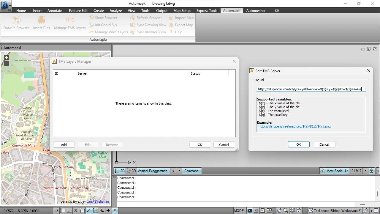
Run the AmTmsLayers command (or click Manage TMS Layers in the Automapki ribbon) to open the tile layer manager. Add a new TMS source and enter the Google Maps Hybrid tile URL:
http://mt.google.com/vt/lyrs=y&hl=en&x=${x}&y=${y}&z=${z}&s=GaThis URL provides Google Maps hybrid tiles - satellite imagery with roads and labels overlaid. Enable the layer to make it available for tile download in the current drawing session.
🌎 Set Coordinate Reference System
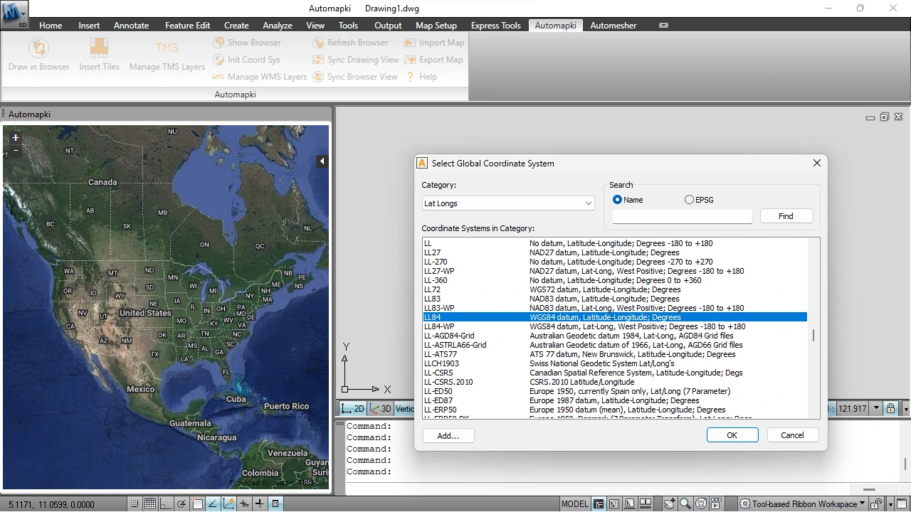
Run the AmSetCoordSys command and assign the coordinate reference system that matches your DWG drawing. This is the critical alignment step - it tells Automapki how to project the map tiles from their native Web Mercator (EPSG:3857) format into your drawing's local coordinate space.
If you skip this step or assign the wrong CRS, the tiles will download but land in the wrong location relative to your drawing geometry. Check the drawing's title block, survey metadata, or .prj file for the correct CRS. Automapki provides over 3,000 predefined coordinate reference systems to choose from.
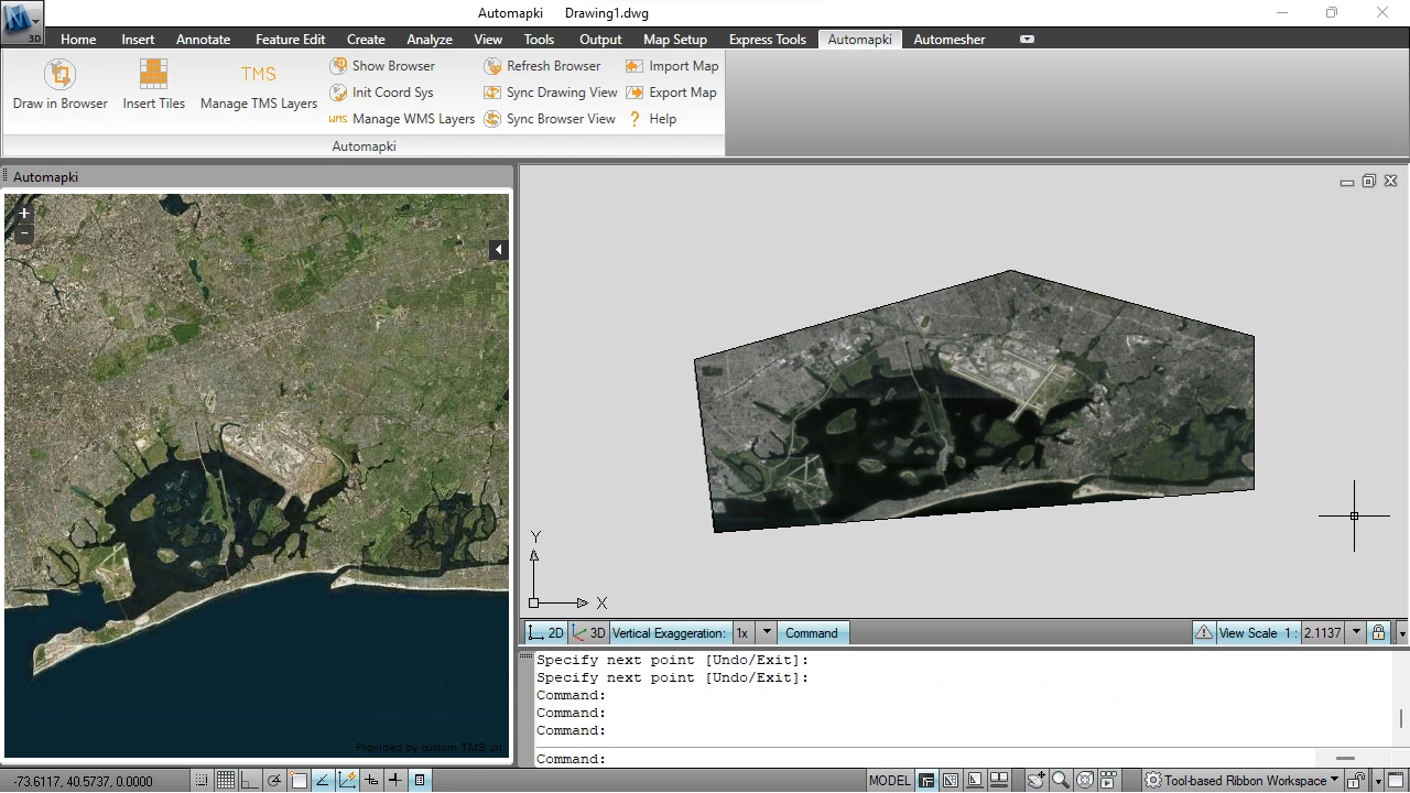
⏬ Download Google Maps Tiles into the DWG
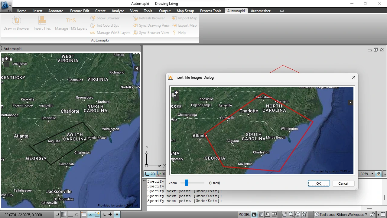
Run the AmInsertTileImages command. Select the map area you want to fill with tiles - typically the extents of your current drawing view or a specific site boundary. Choose the zoom level (higher zoom = more detail but more tiles) and press Enter to download.
Automapki fetches the tiles and inserts them as georeferenced raster images in the DWG model space. The images are placed at the correct scale and position relative to your drawing geometry automatically.
✅ Use Bing Maps as an Alternative (Optional)
If you prefer Bing Maps satellite imagery, add this TMS URL in the AmTmsLayers manager instead:
http://t0.tiles.virtualearth.net/tiles/a${q}.jpeg?g=854&mkt=en-US&token=Anz84uRE1RULeLwuJ0qKu5amcu5rugRXy1vKc27wUaKVyIv1SVZrUjqaOfXJJoI0The workflow is identical to Google Maps - set the CRS, run AmInsertTileImages, and download the tiles. Any WMS or TMS-compatible map service can be added the same way, including OpenStreetMap, Mapbox, Esri World Imagery, and national mapping agency services.
Why Add a Map Background to AutoCAD?
A georeferenced satellite background adds immediate value to any AutoCAD drawing that involves real-world geography. Specific use cases include:
- Site planning and civil engineering - design roads, utilities, and buildings with real terrain context visible behind the DWG geometry
- Surveying and cadastral work - verify that imported survey data aligns with current satellite imagery before submitting drawings
- Urban planning and zoning - present zoning boundaries and development proposals over current aerial photography for planning authority submissions
- Environmental assessments - compare designed infrastructure routes against current land cover and habitat visible in satellite imagery
- Client presentations - communicate design intent clearly by showing proposed work in its real-world context rather than against a blank DWG background
- Construction site management - overlay site layout drawings on current aerial imagery to verify positioning and access routes
Frequently Asked Questions
-
Does AutoCAD support Google Maps natively?
Standard AutoCAD does not connect to Google Maps or any online tile service natively. AutoCAD Map 3D includes some web map connectivity, but it is not available in standard AutoCAD. Automapki adds TMS and WMS map connectivity to standard AutoCAD, BricsCAD, ZWCAD, and GstarCAD.
-
Why do the map tiles appear in the wrong location in my drawing?
This is caused by an incorrect coordinate reference system assignment in Step 3. The tiles are being projected into the wrong local coordinate space. Assign the correct CRS that matches your drawing and re-run AmInsertTileImages.
-
Can I use other map services besides Google Maps and Bing Maps?
Yes. Automapki supports any WMS or TMS-compatible map service. Add the service's tile URL in the AmTmsLayers manager and use it exactly like Google Maps or Bing Maps.
-
Are the downloaded tiles saved permanently in the DWG file?
Yes. The tiles are inserted as raster image objects embedded in the DWG, so the map background is visible when you reopen the file even without an internet connection. Updating to fresher imagery requires re-running AmInsertTileImages for the same area.
-
Is there a free trial?
Yes. Automapki Application is available as a free evaluation download with no time limit on the trial period.
Summary
Adding Google Maps or Bing Maps satellite imagery to an AutoCAD DWG requires a TMS tile connection and correct coordinate system alignment - Automapki handles both in five steps. The result is a georeferenced map background embedded in the DWG, correctly positioned relative to your drawing geometry, and available in all four major DWG-compatible CAD platforms.
👉 Ready to add map backgrounds to your DWG? Download Automapki add-on and try it free.