Standard AutoCAD doesn't support shapefile import or export natively. If you need to bring ESRI SHP data from GIS platforms into your DWG drawing - or export CAD geometry to SHP, KML, GeoJSON, or GPX for use in ArcGIS, QGIS, or Google Earth - you need a plugin that handles both the format conversion and the coordinate system reprojection that makes the data align correctly.
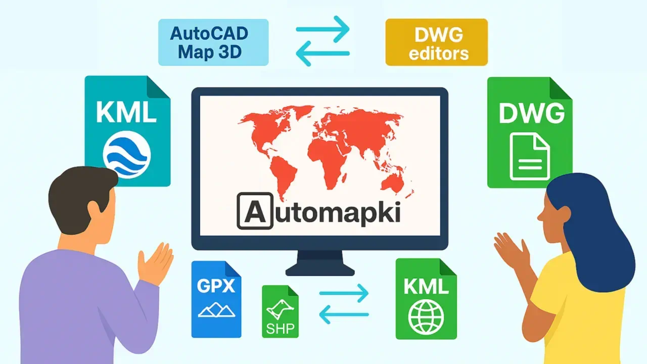
Automapki Application adds georeferenced map import and export to AutoCAD, BricsCAD, ZWCAD, and GstarCAD, supporting SHP, KML, KMZ, GPX, and GeoJSON in both directions - with over 3,000 coordinate reference systems for accurate spatial alignment.
Supported Map Formats
Automapki Application imports and exports the following GIS and mapping formats from inside your DWG editor:
- SHP (ESRI Shapefile) - the primary vector format used by ArcGIS, QGIS, and virtually all GIS platforms; point, polyline, and polygon geometry with attribute tables
- KML / KMZ - Google Earth format for placemarks, boundaries, and raster ground overlays
- GPX (GPS Exchange Format) - GPS track and waypoint data from Garmin, handheld GPS units, and mapping apps
- GeoJSON - open web standard for geographic features used by Mapbox, Leaflet, and web mapping APIs
How to Import a Shapefile (SHP) into AutoCAD
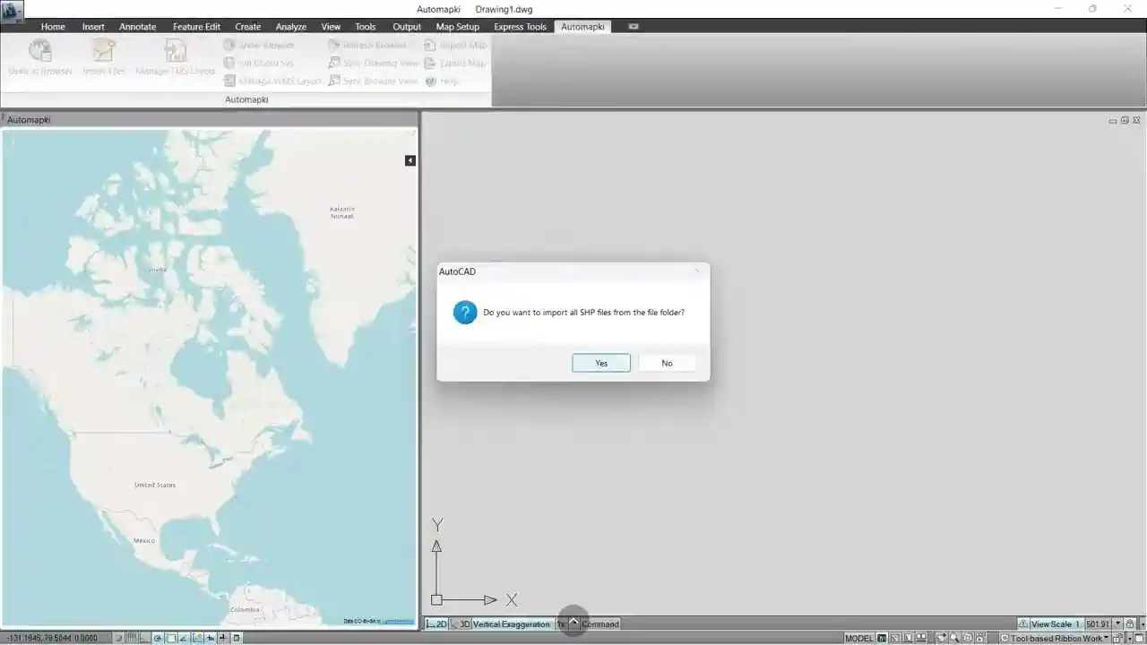
The import workflow uses the AmImportMap command, which handles coordinate system reprojection automatically:
- Install Automapki Application and restart your CAD software to load the plugin. The Automapki ribbon tab appears in AutoCAD, BricsCAD, ZWCAD, or GstarCAD.
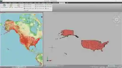
- Set the coordinate reference system using the AmSetCoordSys command - select the CRS that matches your DWG drawing from the library of 3,000+ predefined options. This step is critical: Automapki reprojects the incoming SHP data from its native CRS into your drawing's coordinate space, placing geometry at the correct location relative to your existing DWG entities.
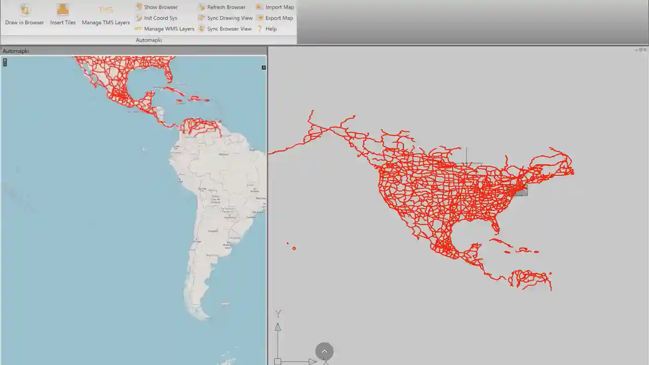
- Click Import Map in the Automapki ribbon or run AmImportMap in the command line. Browse to your SHP file and click Open. The shapefile geometry imports into the DWG model space as points, polylines, and polygons.
Imported features retain their styling where possible. Custom shapefile attributes are preserved as XDATA attached to the imported DWG entities, making the attribute data accessible for annotation or further processing.
How to Export a DWG Drawing to Shapefile (SHP)
The export workflow uses the AmExportMap command:
- Click Export Map in the Automapki ribbon or run AmExportMap in the command line.
- Select the DWG entities you want to include in the export - points, polylines, polygons, or any combination.
- Choose SHP as the output format and specify the output file path. Automapki reprojects the selected geometry from your DWG coordinate system back to the target CRS and writes the SHP, DBF, and PRJ files.
The exported shapefile opens correctly in ArcGIS, QGIS, and any other GIS application that reads ESRI Shapefile format. Custom XDATA properties from the DWG entities are included as attribute columns in the DBF table.
The same workflow applies for KML, KMZ, GPX, and GeoJSON exports - select the format in the export dialog and Automapki handles the rest.
Why Coordinate System Assignment Is Essential
GIS data uses geographic or projected coordinate systems (WGS84, UTM, national grids) while DWG drawings often use local coordinate systems (state planes, survey coordinates, or project-specific origins). Without coordinate system reprojection, imported shapefile geometry lands at incorrect coordinates - sometimes thousands of meters away from the drawing's existing geometry.
Automapki handles this automatically: assign the correct CRS for your DWG once using AmSetCoordSys, and all subsequent imports and exports reproject correctly. With over 3,000 predefined coordinate reference systems - including all EPSG codes, national grids, UTM zones, and state planes - you can find any commonly used system by EPSG code, country name, or projection type.
Frequently Asked Questions
Can standard AutoCAD import shapefiles without Map 3D?
Standard AutoCAD cannot import SHP files natively - this capability requires AutoCAD Map 3D or a third-party plugin. Automapki Application adds full shapefile import and export to standard AutoCAD, as well as BricsCAD, ZWCAD, and GstarCAD.
Why does imported shapefile geometry appear in the wrong location?
This is a coordinate system mismatch. Run AmSetCoordSys and assign the CRS that matches your DWG drawing before importing. Automapki then reprojects the SHP data from its native coordinate system into your drawing's local coordinate space, placing geometry at the correct location.
Are shapefile attributes preserved when importing into AutoCAD?
Yes. Shapefile attribute data from the DBF table is stored as XDATA attached to the imported DWG entities. This data is also written back to the DBF table when exporting DWG geometry that contains XDATA to SHP format.
Is there a free trial?
Yes. Automapki Application is available as a free evaluation download with no time limit on the trial period.
Summary
Automapki Application adds SHP, KML, KMZ, GPX, and GeoJSON import and export to AutoCAD, BricsCAD, ZWCAD, and GstarCAD - with coordinate system reprojection built in. Assigning the correct CRS using AmSetCoordSys is the essential step that ensures imported and exported map data aligns correctly with your DWG geometry. Shapefile attributes are preserved via XDATA in both directions.
👉 Ready to connect CAD and GIS? Download Automapki Application and try it free.