AutoCAD does not export to KML or KMZ natively. If you need to visualize a DWG drawing in Google Earth, share a georeferenced map with stakeholders, or integrate CAD data into a GIS platform, you need to convert the DWG geometry to KML or KMZ first.
This guide shows how to export DWG drawings to KML or KMZ using Automapki Application, a plugin for AutoCAD, BricsCAD, GstarCAD, and ZWCAD. The process handles coordinate system reprojection automatically - so DWG geometry drawn in a local CRS (such as a national grid) lands in the correct geographic position in Google Earth.
Why Coordinate System Setup Is Critical
Google Earth displays everything in WGS84 geographic coordinates (latitude/longitude). Most engineering DWG drawings use a projected local coordinate system - a national grid, state plane, UTM zone, or a site-specific origin. If you export DWG geometry without reprojecting it, the result lands in the wrong location on Earth or fails to display at all.
Automapki resolves this by assigning a source CRS to the DWG drawing before export. It reprojects all geometry from the drawing's local coordinate system to WGS84 automatically during the KML/KMZ export. Getting this step right is the difference between an accurate overlay and geometry in the middle of the ocean.
How to Export AutoCAD DWG to KML or KMZ
⚙️ Install Automapki Application
Download and install Automapki Application for your CAD platform - AutoCAD, BricsCAD, ZWCAD, or GstarCAD. After installation, restart your CAD application. Automapki adds a dedicated ribbon tab and command set for map import and export.
📂 Open Your DWG Drawing
Open the DWG drawing you want to export in your CAD application. The drawing should contain georeferenced geometry - lines, polylines, polygons, or points that represent real-world features in a known coordinate system.
🌎 Assign Coordinate Reference System
Click the Init Coord Sys button in the Automapki ribbon. Select the coordinate reference system that matches your drawing from the library of over 3,000 predefined CRS options - national grids, state planes, UTM zones, and more.
If you are unsure which CRS your drawing uses, check the drawing's metadata, ask the survey or GIS team who produced it, or look for a coordinate note in the title block. Assigning the wrong CRS produces a misaligned export - the geometry will appear in Google Earth but in the wrong geographic location.
📤 Run AmExportMap Command
Type AmExportMap in the AutoCAD command line and press Enter, or click the Export Map button in the Automapki ribbon. Select the entities you want to export - individual objects, a layer, or all geometry in the drawing. Choose your output folder and filename.
To export KML, save with the .kml extension. To export KMZ, change the extension to .kmz - Automapki automatically packages the KML and any associated resources into a compressed KMZ archive.
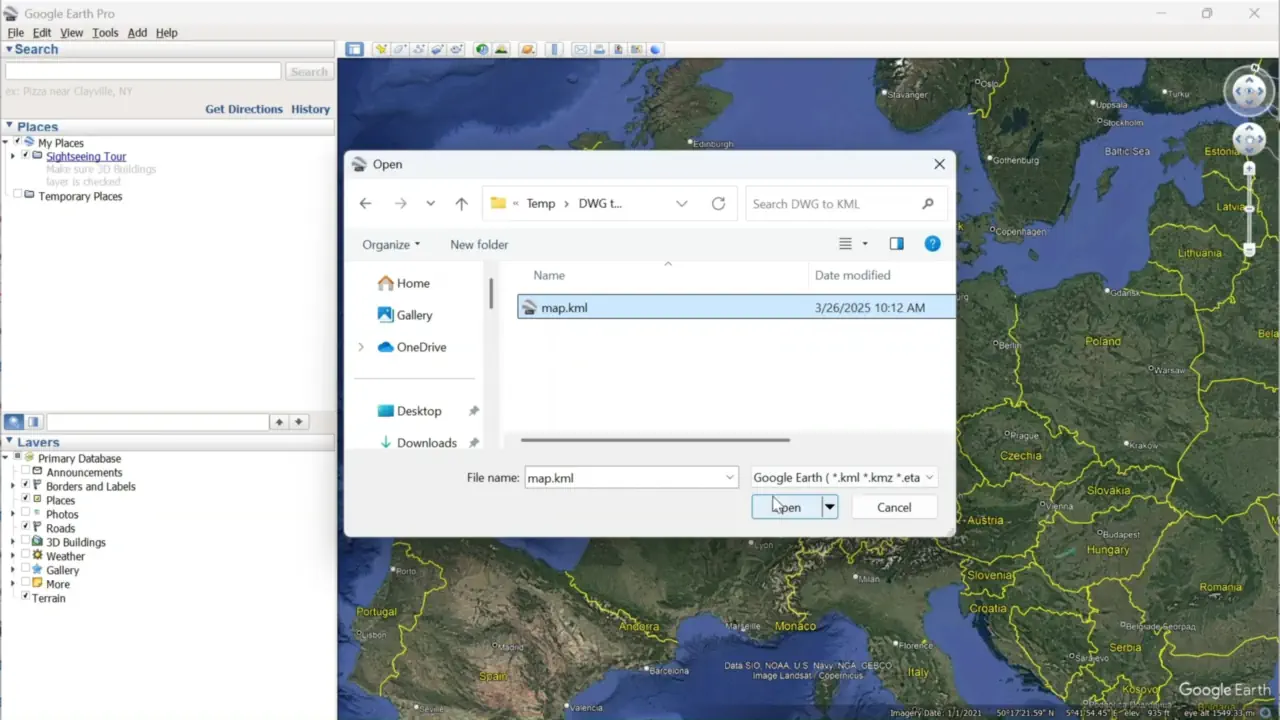
✅ Open and Verify in Google Earth
Open Google Earth Pro and go to File > Open. Select your exported KML or KMZ file. The drawing geometry should appear as an overlay on the satellite imagery at the correct geographic location. Use Google Earth's opacity slider to compare the CAD geometry against the satellite image for alignment verification.
If the geometry appears in the wrong location, the coordinate reference system assigned in Step 3 is incorrect - reassign the correct CRS and re-export.
KML vs KMZ: Which Should You Export?
| Feature | KML | KMZ |
|---|---|---|
| File format Plain | Plain XML text | ZIP-compressed archive |
| File size | Larger | Smaller (compressed) |
| Linked resources | References external files | Bundles all files in one archive |
| Easy to edit | ✅ Yes (open in any text editor) | ❌ Extract first |
| Best for sharing | When editing is needed | ✅ For email and upload |
| Google Earth support | ✅ Yes | ✅ Yes |
| GIS software support | Widely accepted | Varies by application |
Use KML when the recipient needs to edit the geographic data or when the file will be used in a GIS pipeline that processes KML directly. Use KMZ when sharing by email or upload - the single compressed file is easier to transfer and cannot have broken resource links.
Frequently Asked Questions
-
Does AutoCAD export to KML natively?
No. AutoCAD does not include a built-in KML or KMZ export. Automapki Application adds this capability as a plugin, with coordinate system reprojection built into the export process.
-
Why does my exported KML appear in the wrong location in Google Earth?
This is caused by an incorrect coordinate reference system assignment in Step 3. The drawing geometry is being reprojected from the wrong source CRS, resulting in geographic displacement. Reassign the correct CRS that matches your drawing and re-run the export.
-
Does the KML export preserve layer names and entity attributes?
Yes. Automapki maps DWG layer names to KML folder names, preserving the drawing's organizational structure in the output. Entity attributes and block attributes can also be exported as KML extended data.
-
Can I also import KML or KMZ back into AutoCAD?
Yes. Automapki supports bidirectional conversion - use the AmImportMap command to import KML or KMZ files into an active DWG drawing with coordinate system transformation. See the KML to AutoCAD import guide for details.
-
Is there a free trial?
Yes. Automapki Application is available as a free evaluation download with no time limit on the trial period.
Summary
Exporting AutoCAD DWG drawings to Google Earth KML or KMZ requires coordinate system reprojection - without it, geometry appears in the wrong geographic location. Automapki handles the reprojection automatically from a library of 3,000+ reference systems, and the four-step export process works identically in AutoCAD, BricsCAD, ZWCAD, and GstarCAD.
👉 Ready to export? Download Automapki plug-in and try it free.